Companion@360 → 7 Month programme to sharpen your writing skills → REGISTER NOW

UPSC Mains Answer Writing Practice
Check All Mains Questions
1. What do you understand by the theory of continental drift? Discuss the prominent evidence in its support. (10 Marks)
2. Discuss the growth, location and distribution of Iron and Steel Industry in India. (10 Marks)
3. Make a comparative study of the tropical and temperate cyclones. (10 Marks)
4. Why the Pacific ring of fire has a high concentration of volcanoes and high risk of earthquakes? (10 Marks)
5. Discuss the relevance of ‘watershed’ as an ecosystem for the purpose of sustainable development. (10 Marks)
6. “Urban Solid Waste Management poses the greatest challenge in metropolitan planning.” Elaborate. (15 Marks)
7. Evaluate the role of India in the geopolitics of the Indian Ocean. (15 Marks)
8. Do you think a detailed study of lunar surface and structure could help in understanding the Earth better? Also, explain the objectives of the Juno mission in this regard. (15 Marks)
9. Define air masses. How do they originate? Classify them and state the characteristics of any one type. (15 Marks)
10. With the development of electronic industry, the requirement of rare earth minerals is increasing day by day. Discuss the availability and spread of rare earth minerals across India and the world. (15 Marks)
Answer Key
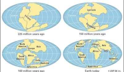
1.What do you understand by the theory of continental drift? Discuss the prominent evidence in its support.
Answer: German scientist Alfred Wegener during early 20th century proposed a theory that the continental landmasses were drifting across the Earth from about 200 million years ago. He called this movement or Continental Drift.
Wegener believed that all the continents had once been joined in a single super continent . This huge ancient landmass is known as Pangea which existed about 240 million years ago and the superocean was known as Panthalassa.
By about 200 million years ago, this super continent began breaking up into two parts namely Gondwanaland and Laurasia separated by Tethys Sea. Pangaea eventually separated into pieces that moved away from one another. These pieces slowly assumed their present positions as the continents.
Factors supporting continental drift:
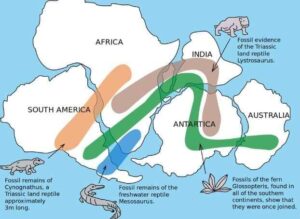
● Wegener noticed that the coasts of Western Africa and eastern South America looked like the edges of interlocking pieces of a jigsaw puzzle which fit each other well.
● Fossils of the ancient reptile mesosaurus are only found in southern Africa and South America. It could not have swum the Atlantic Ocean rather it is found in both locations due to the continents being together in geological timescale.
● The Caledonian and Hercynian mountains of Europe and the Appalachians of USA seem to be one continuous series.
● Presence of placer deposits, tillite deposits in all the continents etc. are also a factor that support the continental drift.
● Carboniferous age glacial sediments, whose presence is observed in several parts also indicates the unity of several continents into one land unit before.
● Common fossil evidences as shown in the figure from different regions are also a factor that support the theory.
The theory of continental drift however faced criticism as it was unable to explain the forces behind the movement of continents. The tidal forces and gravitational forces mentioned by Alfred Wenger was not sufficient to explain the continental movements. The emergence of sea floor spreading theories, plate tectonics etc. became an advancement on the continental drift theory.
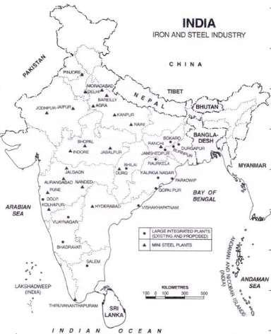
2. Discuss the growth, location and distribution of Iron and Steel Industry in India.
Answer: India produces 101 million metric tons of iron and steel annually making it the third largest producer of the same in the world. The growth of the industry is affected by the availability of suitable geographical factors like raw material, electricity, water resources and other non geographical factors like power resources, skilled labour, adequate land etc.
Iron and steel industry is a weight loss industry. The growth phase of the industry followed the following phases in India:
● Proximity to raw materials: The industries initially were located closer to the iron ore rich areas like Chotanagpur plateau, Kudremukh etc.
● Proximity to market: With the advent of technology, modern means of processing emerged and also the rise of urban cities enabled the establishment of such industries near the urban markets.
● Port centred industries: The next phase of industries became port centred. They focus on exporting the iron ores to the global nations like Japan etc. Such industries are mainly concentrated around Vizag, Paradip etc.
● Mini iron and steel industries: The latest set of evolution in such industries are the emergence of mini iron and steel plants. They require less land as well and can be set up in small towns.
Location and distribution of iron and steel plant:
● The largest iron ore reserves in India are located around the Chotanagpur Bastar region. The Bailadila mines, Dalli- Rajhara mines etc in Chattisgarh provide the inputs for the industries like Korba.
● The reserves from the Bababudan hills are important in the existence of the plants in Karnataka such as Bhadravati iron and steel plant.
● The detail distribution of the iron and steel plant is given below:
3.Make a comparative study of the tropical and temperate cyclones.
Answer: In meteorology, a cyclone is a large scale air mass that rotates around a strong center of low atmospheric pressure. Cyclones are characterized by inward spiraling winds that rotate about a zone of low pressure.
| Parameter | Tropical Cyclone | Temperate Cyclone |
| Latitude | Primarily confined to 5 – 30 North and South latitudes. |
Visible between 30-66 North and South of the equator. |
| Geographical Area | Much lesser. About 50-100 km. | They stretch over 500 to 600 km. |
| Time/Season | Late summer period. ( Between September- November) | Occur mostly in winter, late autumn and spring |
| Formation | They form only on seas with temperature more than 26- 270 C. | Can form both on land as well as seas |
| Wind Velocity | Much greater (100 – 250 kilometre per hour). | Lower. (30-150 kmph) |
| Direction | Wind moves mainly from east to west | Moves mainly from west to east direction. |
| Destruction | More destruction(storm surges, a sudden pour of rains) | Less destruction, often a pleasant climate) |
| Time Period | Mainly exists for 3-4 days. Often dissipates once entering the land |
More time period. Often exists for about three to four weeks |
| Driving Force | Derives its energy from the latent heat of condensation. | The energy of a temperate cyclone depends on the variation in properties of air masses. |
| Influence on India
. |
Both coasts affected. But the east coast of India is the most affected | Bring rains to North – West India. The associated instability is called ‘Western Disturbances |
| Frontal system | Absent. Occurs due to the pressure gradient difference and latent heat of condensation. | The very cyclone formation is due to frontogenesis |
| Shape | Elliptical | Inverted V |
| Location |
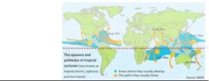
Tropical Cyclone location
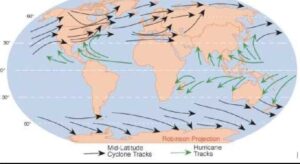
Temperate Cyclone location
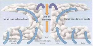
Tropical Cyclone formation
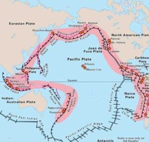
4.Why the Pacific ring of fire has a high concentration of volcanoes and high risk of earthquakes?
Answer: The Ring of Fire is a major area in the basin of the Pacific Ocean where many earthquakes and volcanic eruptions occur. In a large 40,000 km horseshoe shape, it is associated with a nearly continuous series of oceanic trenches, volcanic arcs, and volcanic belts and plate movements.
Seventy-five percent of Earth’s volcanoes, more than 450 volcanoes such as Mt. Mauna Kea. Mt. Fujiyama etc. are located along the Ring of Fire. Ninety percent of Earth’s earthquakes occur along its path, including the planet’s most violent and dramatic seismic events.
Pacific Ring of Fire
The abundance of volcanoes and earthquakes along the Ring of Fire is caused by the amount of movement of tectonic plates in the area. Along much of the Ring of Fire, plates overlap at convergent boundaries called subduction zones. That is, the plate that is underneath is pushed down, or subducted, by the plate above. As rock is subducted, it melts and becomes magma. The abundance of magma so near to Earth’s surface gives rise to conditions ripe for volcanic activity.
5. Discuss the relevance of ‘watershed’ as an ecosystem for the purpose of sustainable development.
Answer: Watershed is defined as a geo hydrological unit draining to a common point by a system of drains. It combines with other watersheds to form a network of rivers and streams that progressively drain into larger water areas.
Relevance of watershed in sustainable development:
● It can play a crucial role in planning for a judicious management of forest ecosystems, and in restoration of degraded soils.
● About 68 million hectare area of the land is lying as wastelands in India. Out of these lands, approximately 50% lands are such non-forest lands, which can be made fertile again if treated properly.
● It can check soil erosion and reduce the effect of sediment yield on the watershed.
● The overexploitation of water resources can be reduced, thereby recharging the depleted ground water table.
● A sustainable management of water resources can increase the agriculture production and livestock productivity as well.
● In watershed management, adequate weed and pest management is also undertaken which help to conserve biodiversity.
● Flood management will be more effective as it helps to moderate the floods peaks at downstream areas.
● It can generate rural employment besides enhancing the people’s participation in the wastelands development programmes at all stages
Case Study: Ralegan Siddhi is a small village in the state of Maharashtra, India. It is a drought-prone and resource poor area with annual rainfall ranging between 50-700 mm and temperature varying between 28°C and 44°C. Following a devastating drought during the 1970’s the place adopted community led watershed management projects. This has widely helped the village to overcome the struggles of poverty.
Read International Relations Notes
6.“Urban Solid Waste Management poses the greatest challenge in Metropolitan planning.” Elaborate.
Answer: According to World Health Organization, the term “Solid Waste” is applied to unwanted and discarded materials from houses, street sweepings, commercial and agriculture operations arising out of mass activities. Urban areas in India generate more than 1 lakh metric tonnes of solid wastes per day. The ever increasing solid wastes in India put pressure on metropolitan cities.
Urban Solid Waste management and the challenges posed to metro planning:
● Collection, processing, disposal, transportation and treatment of such wastes are the responsibility of urban local bodies in India. Capacity constraints in the ULB cause mismanagement of solid wastes.
● Inability of ULB to ensure proper segregation of waste at source and ensure that the waste goes through different streams of recycling and resource recovery cause accumulation of solid wastes into landfills.
● Informal recycling industry is not equipped with adequate technologies like waste to energy conversion plants such as pyrolysis, incineration etc. and thus cause dumping of solid wastes.
● The accumulation of landfills and the wastes cause rampant spread of communicable diseases through water or air. The mismanagement of waste is a cause for diseases like cholera, dysentery, jaundice, typhoid and diarrhoea.
● They are a source of water and soil pollution enhancing the toxicity around the metropolitan areas.
● In addition to these, solid wastes generate emissions of toxic greenhouse gases. It causes a disproportionate rise in the temperature around the urban areas. The microclimate around the urban areas will be disrupted and can accelerate the formation of urban heat islands. Such challenges demand vital actions from the part of government, NGO and local citizens such as:
● Proper enactment and implementation of the Solid Wastes Management Rules, 2016 , Plastic Waste Management Act etc.
●Supreme Court constituted Dr. Burman’s committee to review all aspects of solid waste management and directed the central/state/local bodies to review solid waste management practices.
●Central Pollution Control Board and State Pollution Control Boards have to take steps in order to identify the solid waste processing options depending upon the solid waste composition.
●Waste management rules in India are based on the principles of “sustainable development”, “precaution” and “polluter pays principle.”
The urbanization continues to take place, the management of solid waste is becoming a major public health and environmental concern in urban areas of many developing countries. Solid waste management is therefore a vital, ongoing and large public service system, which needs to be efficiently provided to the community to maintain aesthetic and public health standards.
7.Evaluate the role of India in the geopolitics of the Indian Ocean.
Answer: The geo-political significance of the Indian Ocean stems from the fact that it is a centre piece in the wider Indian Ocean Region. The combination of economic growth and slowdown, military expansion, increasing demand for natural resources, demographics combined with the geo-political situation, increased presence of nuclear capable actors and variances in regional structures of governance, highlights the geo-political significance of this area.
The role of India in the geopolitics of Indian Ocean:
● The Indian Ocean is the third largest water body of the world that has vital sea lanes of communication crisscrossing it and which feeds Asia’s largest economies.
● Around 80 per cent of the world’s seaborne oil trade passes through the choke points of this ocean and therefore it literally connects the east to the west.
● The grant of mining rights for India in the Indian Ocean by the International Seabed Authority to extract polymetallic nodules, presence of methane hydrates in the Indian Ocean increase the resource significance of the region.
● The relations between nations both intra and extra regional shapes the complex matrix that define the overall architecture.
● Oil trade from the West Asian countries, proposed Iran Pakistan India pipeline etc. are important factors in the Indian Ocean as well.
● There has been a gradual to an accelerated expansion of maritime forces and their capabilities in the region. The growing presence of extra regional powers and nuclear capable nations has further altered the existing security framework.
● The economic upsurge of some nations and slowdown of others is throwing up challenges that could affect the regional and international markets.
India has taken proactive measures to gain strength in the Indian Ocean region such as development of Chabahar Port, Duqm port etc. It also actively engages with other nations through regional organisations such as Indian Ocean Rim Association, ASEAN, BIMSTEC etc. Similarly, India is engaging with the major islands in Indian Ocean such as Mauritius and Seychelles through the development of naval bases in Agalega and Assumption islands etc. Yet, the role of India in Indian ocean region faces certain challenges of its own such as:
● The lack of intra-regional trade as compared to the extra-regional trade has limited the relations between nations in the region.
● Added to it is the growing competition and race for exploiting available natural resources, which could bring in new challenges to the region in times to come.
● The chequebook diplomacy of China: the development of Gwadar port, the development of ports around the Indian Ocean through its proposed String of Pearls, Maritime silk roads through its maritime component of OBOR, development of overseas military base of China in Djibouti etc. pose challenge to the supremacy of India.
But more such initiatives need to be taken for increasing India’s base on the Indian Ocean which is the heart of the country.
8.Do you think a detailed study of the lunar surface and structure could help in understanding the Earth better? Also, explain the objectives of the Juno mission in this regard.
Answer: The structure and surface of the moon is believed,can provide valuable insight in to the making of earth due to the following factors:
● Scientists believe that a Mars-sized object crashed into Earth 4.5 billion years ago.Lot of debris from the primordial earth landed between moon dust.
● It’s believed a lot of asteroids hit earth and moon simultaneously during a period called the Late Heavy Bombardment.Unlike earth all these craters are still well preserved on the moon,which can give a picture of similar incidents that happened to earth at that time.
● Discoveries by NASA’s Lunar Renaissance Orbiter indicate that the Moon could have had volcanic flows up to just tens of millions of years ago, during Earth’s dinosaur age.Studying them can give better picture of past volcanic activities on earth.
Juno mission launched by NASA aims to reveal the story of Jupiter’s formation and evolution. Using long-proven technologies on a spinning spacecraft placed in an elliptical polar orbit, Juno will observe
-Jupiter’s gravity
-magnetic fields,
-atmospheric dynamics
-composition
-evolution
Study of Jupiter will give better understanding of earth because;
● It contains many heavy elements which are no longer in Earth’s system
but were originally present.
● Due to extreme atmospheric pressure, Jupiter’s hydrogen turned liquid and formed large oceans. Studying this will help to know how our atmospheric gases behaved during origin of Earth.
● Study of gravitational force that Jupiter exerts on its satellites helps us to better understand gravitational dynamics between earth and moon.
● Jupiter atmosphere gases resembles the state of earth’s atmosphere before it was blown away by solar flares
Origin,evolution,structure of the universe and it’s bodies are still not fully understood and such missions will help providing more insights into them.
9.Define air masses. How do they originate? Classify them and state the characteristics of any one type.
Answer: An air mass is a large mass of air that has similar characteristics of temperature and humidity within it. An air mass acquires these characteristics above an area of land or water known as its source region. When the air mass sits over a region for several days, or longer, it picks up the distinct temperature and humidity characteristics of that region.
Formation of air masses:
● Air masses form over large surfaces with uniform temperatures and humidity, called source regions. Low wind speeds let air remain stationary long enough to take on the features of the source region, such as heat or cold
● Atmospheric stability and absence of atmospheric turbidity is essential for the formation of air masses. The air mass formation is helped by the absence of vertical movements and intermixing of air which lead to its destruction.
● Upper air divergence aids in the existence of air mass as well. At such zones there will be lower air low pressure and winds converge in the lower air and the air parcel moves up diverging into different directions. This helps in preserving the air masses.
Classification of air masses:
● Air masses are classified according to the temperature and moisture characteristics of their source regions.
● Bases on moisture content: continental (dry) and maritime (moist)
● Based on temperature: tropical (warm), polar (cold), arctic (extremely cold)
Distribution of Air mass around the world
Characteristics of Continental Polar Air Mass:
●Continental Polar air masses form over large, high latitude land masses, such as northern Canada or Siberia.
●cP air masses are cold and extremely dry.
●Wintertime cooling over these land areas cause the atmosphere to become very stable (even inversion).
●The combination of dry and stable conditions ensure that few if any clouds form over a cP source region.
Summer cP air masses are similar to winter cP, but much less extreme and remain at higher latitudes.
10.With the development of electronic industry, the requirement of rare earth minerals is increasing day by day. Discuss the availability and spread of rare earth minerals across India and the world.
Answer: :Rare earth are any of a group of chemically similar metallic elements comprising the lanthanide series and (usually) scandium and Yttrium minerals.Comprising a total of 17 elements that are not especially rare, but they tend to occur together in nature and are difficult to separate from one another.
They are widely used in electronic industries ranging from daily use devices like television,refrigerator,mobile phones to high end technologies like quantum computing and artificial intelligence.
Availability and spread in India;
● India holds about 6% of the world’s rare earth reserves. India however produces less than 2% of the total Rare Earth (RE)Oxide produced globally.
● Significant rare earths minerals found in India include ilmenite, sillimanite, garnet, zircon, monazite and rutile, collectively called Beach Sand Minerals (BSM).
● India has almost 35 per cent of the world’s total beach sand mineral
deposits.
Availability and spread in world
● As of 2017, China has 36.6% of world resources, followed by Vietnam which has 18.3% of resources.
● As new technological innovations are making the extraction of rare earth minerals easier it’s production has been increasing and more countries are venturing into its mining.